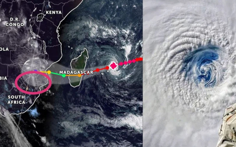
Will Cyclone Freddy hit South Africa?
Tropical Cyclone Freddy has been circulating in the Indian Ocean for the past week, slowly drifting westwards, and currently about 400km north-east of Mauritius. ALSO READ: Cyclone recovery expected to cost New Zealand billions CYCLONE FREDDY TO PASS NEAR MAURITIUS The cyclone is predicted to pass near Mauritius and La Reunion islands and is moving at […]

Tropical Cyclone Freddy has been circulating in the Indian Ocean for the past week, slowly drifting westwards, and currently about 400km north-east of Mauritius.
ALSO READ: Cyclone recovery expected to cost New Zealand billions
CYCLONE FREDDY TO PASS NEAR MAURITIUS
The cyclone is predicted to pass near Mauritius and La Reunion islands and is moving at 31km/h.
This with average winds of around 200km/h and central pressure of 939 hPa.
The WMO’s designated RSMC has predicted that Cyclone Freddy will continue moving towards the west-southwest, towards Madagascar’s east coast.
It will make landfall on Tuesday evening.
ALSO READ: Power, water return to cyclone hit New Zealand cities
Freddy will weaken once it makes landfall, but the remnants will swirl over the southern half of Madagascar.
Cyclone Freddy is then expected to move towards the southern Mozambique Channel.
Here the sea-surface temperatures of 28-29°C will lead to its re-intensification.
WOULD THIS AFFECT SOUTH AFRICA?
Despite the above, RSMC La Reunion’s current official, highest confidence track suggests that Cyclone Freddy might make landfall this Friday, 24 February near Beira, a large port city roughly midway along the Mozambican coastline.
There is a possibility, albeit small, that Cyclone Freddy could move inland.
It could possibly affect eastern Zimbabwe and perhaps the north-eastern sector of Limpopo province.
In the event of the latter scenario, even the weakened, dissipating remnants of Cyclone Freddy could still deliver significantly heavy rainfall.
ALSO READ: Cyclone Batsirai death toll rises to 30 in Madagascar
It also has the possibility of extensive flooding.
Any renewed flooding over the last-mentioned regions could potentially be catastrophic.
This given the recent (unrelated) flooding that affected Limpopo and Mpumalanga last week.
The SA Weather Service (SAWS), in consultation with National and Provincial Disaster Management structures, will continue to monitor developments on a 24/7 basis.
