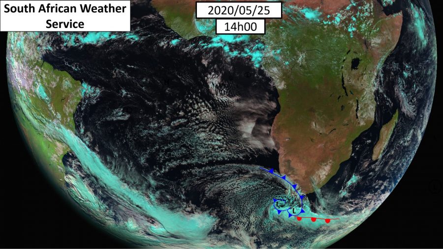
“It’s a Monster” Storm Approaches South Africa
The weather service has predicted a monster of a cold front and storm conditions approaching South Africa. “It’s a monster! Check the sheer size of this MASSIVE COLD FRONT as captured by EUMETSAT (the European Union’s meteorological satellites),” tweeted Gauteng Weather. “It spans from just below SA & over parts of the Cape, through the […]

The weather service has predicted a monster of a cold front and storm conditions approaching South Africa.

“It’s a monster! Check the sheer size of this MASSIVE COLD FRONT as captured by EUMETSAT (the European Union’s meteorological satellites),” tweeted Gauteng Weather. “It spans from just below SA & over parts of the Cape, through the south west Atlantic Ocean. This beast comes with a whopping 10 warnings & watches!!!”
The SA Weather Service said today, “This intense cold front is situated over the south-western parts of the country. Gale force winds, high seas, storm surge and snowfall expected. Alerts will be updated this afternoon.”
The intense cold front would reach the central interior on Tuesday. Areas expected to have cold to very cold temperatures, Western Cape, Eastern Cape, Free State, Northern Cape, North West and southern Gauteng.
It also issued a warning saying that the Sutherland area in the Northern Cape should expect light snow until Tuesday. It also predicted big gales and stormy seas between Cape Columbine and Plettenberg Bay.

First snow in Worcester:
https://www.facebook.com/photo.php?fbid=1136737433386577&set=pcb.2951343118313752&type=3&av=184548831948&eav=AfaSUarQLDEyA9cdGA-EqCcMOjLyQyy0UTNSF00tkBIY5Yw_qNhiIBJPayEc6PrzXHc&theater&ifg=1
https://www.facebook.com/stormreportsaOFFICIAL/photos/a.776032682459401/3039671946095452/?type=3&theater
Towsrivier in the Western Cape
https://www.facebook.com/stormreportsaOFFICIAL/photos/a.789905681072101/3039716062757707/