Space science thriving in SA
South Africa’s space industry is thriving – this is the message relayed to the public by professionals in the sector at a recent media briefing in Cape Town. The event also commemorated humankind’s first foray into space 50 years ago, when Russian cosmonaut Yuri Gagarin spent 108 minutes looking at a view of the earth […]

South Africa’s space industry is thriving – this is the message relayed to the public by professionals in the sector at a recent media briefing in Cape Town.

The event also commemorated humankind’s first foray into space 50 years ago, when Russian cosmonaut Yuri Gagarin spent 108 minutes looking at a view of the earth that nobody had experienced before. At a general assembly earlier in 2011, the UN declared 12 April as the International Day of Human Space Flight.
The milestone was celebrated around the world, including South Africa, where experts in the local space industry came together in the Mother City to discuss the latest developments and current status.
To mark the anniversary, Russian cosmonaut Valery Tokarev visited South Africa as a guest of the newly launched South African National Space Agency (Sansa).
A former space commander and Red Army test pilot, Tokarev addressed several institutions during his tour of the country, including Pretoria’s Innovation Hub and the Cape Peninsula University of Technology (CPUT), which runs a flourishing satellite programme.
Investing in space science
“Can our government afford not to invest in space science?” said Sias Mostert, CEO of Space Commercial Services, opening the media briefing in Cape Town.
Mostert revealed that the country had already invested billions in this field over the last three decades, and had been willing to do so because space science answers questions that are important to human existence.
“Space science has improved the lives of South Africans through applications such as GPS. It’s enabled us to have a better standard of living at lower cost, and it’s helped us to increase productivity so that we can earn better wages,” he said. “It also helps us to better understand our natural environment.”
South Africa is collaborating with Kenya, Nigeria, Egypt and Algeria, in an initiative known as the African Resource Management Constellation, to launch a fleet of satellites that will help African nations to more effectively manage their natural resources, and better monitor disasters. The latter three nations also have space agencies.
“A satellite is a powerful way for a country to show its global status,” said Mostert, “as it makes a strong geo-political statement.”

Advances in local earth observation
South Africa’s first satellite was called Sunsat, and was built as a Stellenbosch University postgraduate project. The 64kg device launched in 1999 aboard a Nasa vehicle.
The same team, which was soon to evolve into satellite solutions provider SunSpace, then built another, bigger satellite and followed this achievement with a third device, the successful earth observation satellite SumbandilaSat.
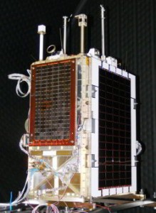
SumbandilaSat, which took only 12 months to build, launched in September 2009 aboard a Soyuz 2.1b rocket from Baikonur in Kazakhstan. Contrary to media reports, it’s already proved its worth in the field of earth observation.
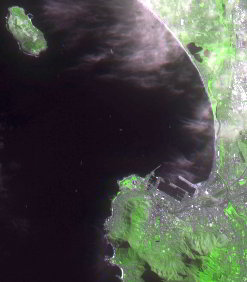
According to the Council for Scientific and Industrial Research (CSIR), the satellite – whose name means “clear the way” or “pathfinder” in Tshivenda – recently produced five high-resolution images of the south-western Kruger National Park in Mpumalanga, as well as the nearby community of Bushbuckridge.
The CSIR team stated that had they bought the images, which are related to CSIR and South African National Parks research projects, they would have paid upwards of R40 000 (US$5 800) per image to an international

supplier. However, SumbandilaSat is able to provide local users with the images they need at no cost.
The 81kg satellite has taken more than 1 250 images of locations around the world, all at a good resolution of 6.25 metres per pixel and an area of 300 square kilometres per image, from its low-earth orbital height of around 500km.
While this imaging capacity is not as great as other bigger and more expensive commercial satellites, SumbandilaSat is still expected to make a huge contribution to earth observation in South Africa.
The device is advancing sectors such as communication, navigation and defence. Its images can be applied to the detection of illegal mining activity, reconnaisance of the country’s borders, monitoring of land degradation, calculation of the extent of land used for agricultural purposes, and more.
Interested parties may request Sumbandila images from Sansa’s earth observation data catalogue.
Using space for peaceful purposes
Sansa, which officially started operations at the beginning of April 2011, has the aim of promoting the peaceful use of outer space, as well as furthering South Africa’s national space strategy.
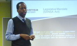
Sansa’s CEO Sandile Malinga, speaking at the briefing, said that the agency is to focus on building international partnerships; stimulating the economy; developing relevant skills and technology; and using space for the benefit of citizens.
“Developing countries also need a space agency,” said Malinga, “because space science and technology has a broad impact on our activities. In South Africa we’ll use data for environment and natural resource monitoring and management, which will help with urban and rural planning, and economic development.”
Sansa is planning a successor to Sumbandila, but the organisation is still waiting for a firm funding commitment – although, said Malinga, an agreement has been reached in principle.
The new device will capture images at 2.5 metres per pixel, a much higher resolution than that offered by Sumbandila.
“It will be an improvement on Sumbandila,” said Malinga, “which has completed over 6 000 orbits and given us great value for money”.
African space science hub
Research physicist Lee-Anne McKinnell of Sansa Space Science (SSS) – formerly known as the Hermanus Magnetic Observatory – said that SSS aimed to be a hub for earth-space science and technological services in Africa by 2015.
“We’re in a geographically advantageous position,” she said, “located in the South Atlantic anomaly”.
This is the name of the area where the earth’s inner Van Allen radiation belt – a band of energetic charged particles, or plasma, which runs around the planet and is held in place by its magnetic field – comes closest to the earth’s surface.
SSS keeps an eye on eruptions from the sun, and also monitors fluctuations in the earth’s magnetic field. It has been designated as the regional warning centre for space weather, one of 13 around the world, for the African continent. Part of its function is to carry out near-real-time monitoring of space weather and the resultant impact on biological organisms and electronic devices.
“This is the only place in South Africa where we measure the earth’s magnetic field,” said McKinnell. “Hermanus is a clean environment in magnetic terms. There are no disturbances such as an electric rail system, which would interfere with our measurements.”
SSS also offers technological services to the defence and aerospace industries, such as the maintenance and accurate calibration of landing compasses for aircraft, which are all required to have a manual compass on board in case electronics systems fail.
Developing specialised skills for SA’s space industry
At the Cape Peninsula University of Technology a micro-satellite programme is in full swing under the guidance of CPUT Satellite Systems lecturer Francois Visser, also a speaker at the briefing.
The satellite development programme operates from the French South African Technology Institute (F’SATI), a graduate school for engineers and communication specialists.
One of the goals of the programme, which is funded by the Department of Science and Technology through the National Research Foundation, is to rapidly develop specialised skills to support South Africa’s growing space industry.
Full-time students will graduate in 24 months with a masters degree or doctorate, while part-timers will need at least three years to complete their studies. Tuition is offered through agreements with partner institutions in France, including the universities of Paris-Est Créteil and Versailles Saint-Quentin.
Using the innovative Cubesat technology, F’SATI students are currently building two satellites. Cubesat is a modular system that is used throughout the world, with over 40 Cubesats circling the earth to date.
“We’re building a 3U and a 1U satellite,” said Visser, referring to the building blocks of 10x10x10cm that make up each Cubesat unit. A 3U satellite will therefore have dimensions of 10x10x30cm.
“It weighs about four kilos and is the size of a loaf of bread,” said Visser. “We hope to finish the prototype by October 2011 and have it ready for launch, most likely on an Indian vehicle, in the first quarter of 2012 with a science payload.”
The payload will include an earth imaging camera; a radio frequency beacon to calibrate the radar antenna patterns at the SSS’s Antarctica base; and other radio experiments.
Visser described the project as a simple mission that will give all the students valuable experience in satellite mission development and operation. The team plans to demonstrate the satellite at the upcoming International Astronautical Congress, taking place in Cape Town in October 2011.
