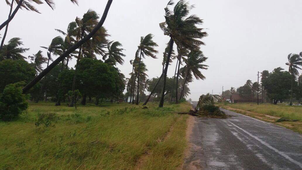
First Pictures & Videos of Cylone Dineo as South Africa Braces for Storm with Special Team
A multi-stakeholder team, comprising members of South African Police Services (SAPS), SA National Defence Force(SANDF), traffic officials, SASSA and Ambulance services, has been assembled by the Limpopo Department of Cooperative Governance – following the warning of severe tropical storm “Dineo”… The South African Weather Services (SAWS) issued an alert about Dineo which formed in the […]

A multi-stakeholder team, comprising members of South African Police Services (SAPS), SA National Defence Force(SANDF), traffic officials, SASSA and Ambulance services, has been assembled by the Limpopo Department of Cooperative Governance – following the warning of severe tropical storm “Dineo”…
The South African Weather Services (SAWS) issued an alert about Dineo which formed in the Mozambique channel.
The first pictures are in of the cyclone hitting Mozambique Wednesday evening.
Some of the pictures from Mozambique, as cyclone #Dineo hits. #sabcnews pic.twitter.com/ZUXPqnQuZL
— Mweli Masilela (@mwelimasilela) February 15, 2017
Situation in Inhambane Mozambique as cyclone #Dineo hits. Clip from Rita Almeida, who's part of the disaster management team. #sabcnews pic.twitter.com/B9LPuIsy12
— Mweli Masilela (@mwelimasilela) February 15, 2017
Cyclone #Dineo video from Mozambique Disaster Management official Rita Almeida. They are expecting situation to be worse tomorrow #sabcnews pic.twitter.com/fFeRz2AVFd
— Mweli Masilela (@mwelimasilela) February 15, 2017
VIEW LATEST CYCLONE DINEO UPDATES – PHOTOS & VIDEOS
According to the SAWS, the greatest impact, with respect to South African provinces, is suggested to be overnight Thursday and into the morning hours of Friday the 17th, when heavy rain can be expected over the entire eastern half of Limpopo, including the Kruger National Park, where 100 to 200mm of rain could occur per day.
“By early Friday morning, the surface vortex (core) of Dineo should begin dissipating in the region of Musina and Beit Bridge in the northern part of Limpopo province.”
SAWS said by Saturday, the remnants of Dineo are expected to drift into Botswana and showers are expected to continue over Limpopo.
The provincial Department of Cooperative Governance said according to previous experiences, flooding normally leads to water overflowing its normal channels such as streams and storm water drains damaging low lying bridges and roads.
“It can as well potentially cause serious problems to public and private infrastructure such as dams and storm water systems. People living in informal settlements and those located in floodplains and farms are mostly at risk,” the department said on Wednesday.
South African Cyclone Dineo Contingency plan
“Arising from this alert, we have developed a contingency plan to mitigate and respond to this possible disastrous event. All district municipalities were informed about the approaching cyclone. National Disaster Management centre will activate the helicopter in case of need,” the department said.
The Provincial Disaster Management Centre (PMDC) says it will activate all its resources including the staff. The Prov-Joint operations centre will be activated on Thursday at 12h00.
In addition, the following precautionary measures have been undertaken.
- District Disaster Management officers, CDWs, Ward Councillors and community-based organisations have been enlisted to assist with the reporting of incidences to improve turnaround time.
- Early warning SMS service has been activated for all partners to receive information from the South African Weather Services (SAWS) on disaster alerts.
As part of the plan, all Districts and Local Disaster Centres in municipalities have also been prepared to step in at any given moment.
They have been allocated with resources and have plans in place to intervene should anything happen.
The toll free number: 0800 222 111 has been activated for 24 hours diverted to Senior Management after hours.
Warning to communities in South Africa
The department has reemphasised the call they made during the festive season for community members in affected areas to remain indoors if possible.
“We further reiterate the need for pedestrians and motorists to stay off the roads and avoid crossing rivers and swollen streams where water is above normal ground,” the department said.
The following measures may also be useful to members of the public:
- If trapped in flooding in a vehicle, abandon it and climb to higher ground.
- In the buildings, move valuables to a safe place above the expected flood level.
- Switch off electricity at the supply point to the building.
- In rural areas protect/relocate animals to a safe place on higher ground. Abandon your home immediately if evacuation is recommended, before access is cut off by flood water.
- Never drive on a road covered by water as you do not know how deep it is or if the road has been washed away. If the vehicle stalls, leave it immediately and seek higher ground.
- Be especially cautious at night when it’s harder to recognize flood dangers. Listen to the radio or TV for warnings and obey the instructions from disaster management officers.
SAWS said it was important to remember that such tropical systems, which originate over open water, are critically dependent on the open ocean as a source of latent heat energy in order to sustain their growth and intensification.
“The moment such systems move overland (as is the case with Dineo later today), they invariably undergo rapid structural weakening and decay,” the weather service said.
SAWS will continue to monitor any further developments relating to this weather system and will issue updates as required.
Source: SAnews.gov.za
